On 22 April 2026, Sheikh Mohammed bin Rashid Al Maktoum, Vice President and Prime Minister of the UAE and Ruler of Dubai, announced the Dubai Metro Gold Line — the single largest transport investment in the emirate’s history. The Dh34-billion project is not merely another extension of an existing rail corridor; it is a structural transformation of how Dubai moves.
Stretching 42 kilometres, bored entirely underground at depths reaching 40 metres, and threading through 15 of the city’s fastest-growing districts, the Gold Line will serve an estimated 1.5 million residents when fully operational by 2040. Daily ridership is projected at 465,000 passengers beyond that year. For context, the line adds 35 per cent more track to a network that already carries one million passengers every single day.
Key Facts at a Glance
This isn’t an incremental upgrade to an existing corridor — it’s a ground-up reimagining of how Dubai’s rail network is structured. The scale of the investment, the depth of the tunnels, the ridership projections, the timeline — every metric points to a project that is genuinely without precedent in the emirate’s history. Before diving into the route and stations, it’s worth pausing on those numbers and letting them land properly.
| Metric | Detail |
| Total cost | AED 34 billion (~USD 9 billion) |
| Length | 42 kilometres, fully underground |
| Maximum depth | 40 metres below surface |
| Number of stations | 18 stations across 15 strategic areas |
| Opening date | 9 September 2032 |
| Daily ridership (2040+) | 465,000 passengers |
| Residents served | 1.5 million by 2040 |
| Network expansion | From 120 km to 162 km (+35%) |
| Station count (total) | 67 → 85 stations across full network |
| Red Line congestion relief | 23% reduction between Burjuman & ONPASSIVE |
| Annual journey reduction | Over 40 million fewer road trips |
| Construction speed | 30% faster than the Blue Line |
The Gold Line Route: From Heritage to the Future
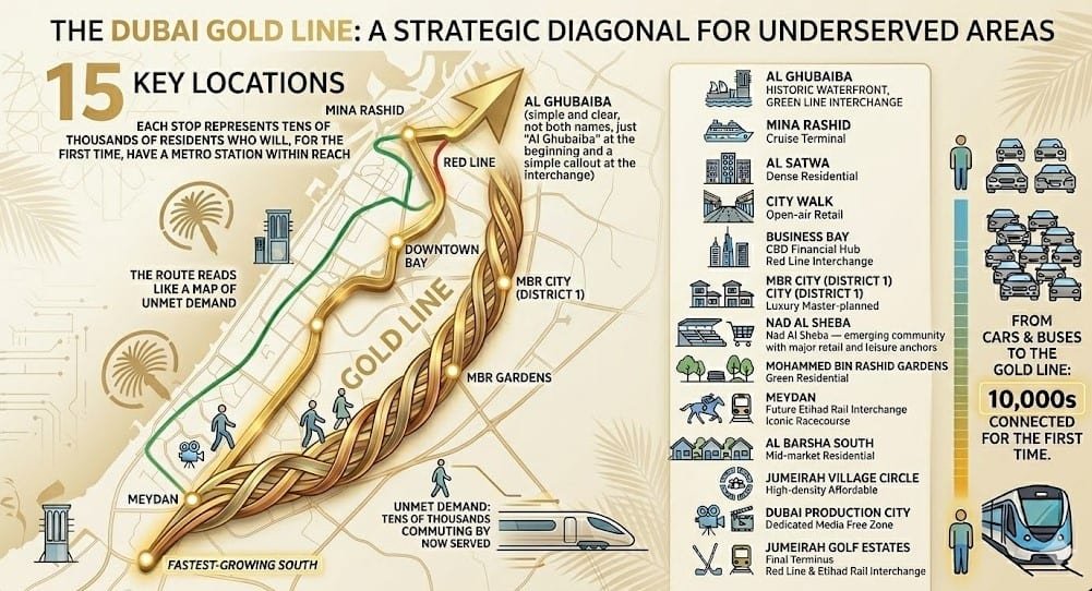
The Gold Line traces a bold diagonal across Dubai’s urban landscape, starting in the historic district of Al Ghubaiba — home to the existing Green Line interchange — and cutting south-west through modern high-density corridors before terminating at Jumeirah Golf Estates, where both the Red Line and Etihad Rail converge.
Unlike the Red and Green Lines, which run largely elevated along major arterials, every metre of the Gold Line runs underground. Tunnel-boring machines will carve through loose sand and limestone, at some points passing 40 metres beneath active motorways and dense residential towers — a feat that engineers have described as one of the most technically demanding metro projects ever attempted in the Middle East.
Related : How Dubai Air Taxi Project Came Together + Top 4 Vertiports
Route Corridor — 15 Strategic Areas
One of the most telling things about the Gold Line is where it goes — and where it doesn’t. Rather than reinforcing already well-connected corridors, it cuts a deliberate diagonal through districts that have long been underserved by the existing network.
Starting from the historic waterfront at Al Ghubaiba in the north and driving south-west through some of Dubai’s most densely populated and fastest-growing communities, the route reads almost like a map of unmet demand.
Each stop along the way represents tens of thousands of residents who currently commute by car or bus, and who will, for the first time, have a metro station within reach. These are the 15 strategic areas the line passes through, in sequence from north to south:
- Al Ghubaiba — historic waterfront, Green Line interchange
- Mina Rashid — cruise terminal and maritime heritage zone
- Al Satwa — one of Dubai’s most densely populated residential communities
- City Walk — European-style open-air retail and entertainment district
- Business Bay — Red Line interchange and CBD financial hub
- Mohammed Bin Rashid City (District 1) — luxury master-planned mega-development
- Nad Al Sheba — emerging community with major retail and leisure anchors
- Mohammed Bin Rashid Gardens — master-planned green residential development
- Meydan — future Etihad Rail interchange; iconic racecourse destination
- Al Barsha South — established mid-market residential zone
- Jumeirah Village Circle — high-density affordable residential community
- Dubai Production City — dedicated media free zone
- Jumeirah Golf Estates — final terminus; Red Line and Etihad Rail interchange
All 18 Stations: Locations and Connections
The Roads and Transport Authority (RTA) has released a 2032 network map from which station positions can be clearly identified. Below is a complete breakdown of every stop on the Gold Line, along with its key connections and neighbourhood highlights.
| # | Station | Key Connections / Highlights |
| 1 | Al Ghubaiba | Green Line interchange; near Dubai Creek & City Centre Al Shindagha |
| 2 | Al Mina Street | Access to Etihad Museum, Port Rashid Passengers Terminal |
| 3 | Al Satwa (Bus Station) | First-ever metro stop serving Satwa; intercity bus links |
| 4 | Al Satwa Road | Second Satwa stop; serves one of Dubai’s densest neighbourhoods |
| 5 | City Walk | Near Coca-Cola Arena, The Green Planet, dining & retail |
| 6 | Business Bay | Red Line interchange; central hub for business & leisure |
| 7 | Burj Khalifa Road | Additional Downtown access; eases Red Line congestion |
| 8 | District 1 (North) | Mohammed Bin Rashid City; near High Speed Rail corridor |
| 9 | District 1 (South) | Second stop serving the luxury MBR City development |
| 10 | Nad Al Sheba | Nad Al Sheba Mall, The Square, Hewi Dubai |
| 11 | Dubai Hills | Serves 100,000+ future residents; Dubai Hills Mall & golf course |
| 12 | Global Village | First metro access for Dubai’s most-visited leisure attraction |
| 13 | Meydan | Future Etihad Rail interchange; Meydan Racecourse |
| 14 | Hadaeq MBR | Master-planned community with 70+ gardens; Japanese-inspired design |
| 15 | Dubai Miracle Garden | Station near world’s largest natural flower garden |
| 16 | Jumeirah Village Circle | Popular residential community; growing demand hub |
| 17 | Dubai Production City | Free zone for media; City Centre Me’aisem |
| 18 | Jumeirah Golf Estates | Red Line & Etihad Rail interchange; final terminus |
Network Integration: Connecting Dubai’s Transit Grid
One of the Gold Line’s most important contributions is how it knits together transport layers that currently operate in parallel. The line creates four interchange points with existing and forthcoming rail services.
Red Line Connections
The Gold Line intersects the Red Line at two locations. Business Bay brings a new metro entry point into the very heart of the city’s commercial district, alleviating the notorious peak-hour crush on the existing station. At the southern terminus, Jumeirah Golf Estates creates a dual interchange with both the Red Line and Etihad Rail — making it the most connected station outside of Union.
Green Line Connection
Al Ghubaiba, the northern starting point of the Gold Line, already serves as a Green Line station. The interchange will allow passengers travelling from Deira and the Creek area to switch seamlessly onto the Gold Line without accessing the road network. This is particularly relevant for communities along the Bur Dubai waterfront that currently depend almost entirely on buses and private vehicles.
Etihad Rail Integration
The Gold Line’s integration with the national Etihad Rail network at two points — Meydan (designated as a future passenger interchange) and Jumeirah Golf Estates — represents a structural step forward in UAE-wide connectivity. Once Etihad Rail’s passenger service is operational, travellers will be able to ride from Abu Dhabi or Sharjah directly onto the Dubai Metro network without changing transport modes at the edge of the emirate. This alignment with a national rail spine places the Gold Line well beyond the scope of a city metro.
No Direct Blue Line Connection — Yet
It is worth noting that the Gold Line and the Blue Line — currently under construction and scheduled to open on 9 September 2029 — do not share an interchange station based on current RTA maps. The two lines are being built simultaneously, which adds considerably to the project’s engineering complexity. Future network plans may address this gap, but no official announcement of a Blue-Gold interchange has been made.
Blue Line vs Gold Line: How the Two New Lines Compare
| Feature | Blue Line | Gold Line |
| Cost | AED 18 billion | AED 34 billion |
| Length | 30 km | 42 km |
| Stations | 14 | 18 |
| Track type | Partly underground, partly elevated | Fully underground |
| Max depth | — | 40 metres |
| Opening date | 9 September 2029 | 9 September 2032 |
| Key corridors | Jaddaf, Festival City, International City, Silicon Oasis, Mirdif | Satwa, Business Bay, MBR City, Dubai Hills, JVC, JGE |
| Red Line link | Centrepoint (Al Rashidiya) | Business Bay & Jumeirah Golf Estates |
| Green Line link | Creek Station (Al Jaddaf) | Al Ghubaiba |
| Etihad Rail link | None confirmed | Meydan (future) & Jumeirah Golf Estates |
| Special record | World’s tallest metro station (74m) | Deepest & longest fully underground line in Dubai |
Building 40 Metres Underground
The Gold Line’s engineering ambition is difficult to overstate. Constructing a fully underground metro through an already built-up city is among the most complex civil-engineering challenges in the world. Dubai’s geology — loose sand layered over limestone — compounds the difficulty significantly.
Tunnel-boring machines (TBMs) will be deployed across multiple simultaneous fronts. The total underground tunnel length added will be equivalent to twice the entire existing Dubai Metro tunnel network. This is being achieved while the Blue Line is already under construction, requiring extraordinary co-ordination between two mega-projects sharing urban space and contractor ecosystems.
The project director from Arthur D Little Middle East has highlighted that the 40-metre depth introduces serious requirements around fire safety, ventilation, emergency egress, and station pressurisation that are largely unprecedented in Gulf metro design. Authorities have committed to completing the project 30 per cent faster than the Blue Line, which is itself a benchmark for regional infrastructure delivery.
Impact on Dubai’s Transport Network and Real Estate
Traffic and Congestion Relief
The Gold Line is projected to remove more than 40 million car journeys from Dubai’s road network every year. The Red Line between Burjuman and ONPASSIVE is among the most congested sections of the existing metro, operating close to capacity at peak hours. The Gold Line’s parallel routing through Business Bay and the southern suburbs is specifically designed to draw passengers away from that corridor, reducing pressure by an estimated 23 per cent.
Unlocking Under-Served Communities
Areas such as Al Satwa, Al Barsha South, Dubai Hills, Jumeirah Village Circle and Dubai Production City have long been home to large residential populations with limited metro access. Satwa in particular — one of the city’s most densely populated neighbourhoods — is served today only by a bus network, with the nearest metro stops requiring a 20-minute walk. The Gold Line changes that entirely.
Real Estate and Property Values
Historical patterns from the Red and Green Line launches show that metro connectivity consistently strengthens residential demand and rental values in adjacent communities. JLT, Dubai Marina and parts of Al Barsha all saw notable demand growth after their respective lines opened. RTA data projects that property values near Gold Line stations could appreciate by up to 20 per cent, while urban planning experts note that improved connectivity tends to unlock value in districts previously considered secondary.
Real estate professionals already note a shift in how buyers and tenants prioritise location: proximity to a metro station now frequently outweighs the prestige of a central address, particularly as the network pushes further into the city’s western and southern corridors.
Environmental and Sustainability Gains
The RTA projects a 430 per cent cumulative economic return over 20 years of Gold Line operation, driven by time savings, fuel savings, reductions in road fatalities and measurable cuts to carbon emissions. At a macro level, the London School of Economics has noted that mass rail systems in rapidly growing Gulf cities can meaningfully reduce car dependency — provided station access is supported by walkable neighbourhoods and seamless feeder bus services.
Project Timeline
| Phase | Date |
| Announcement | 22 April 2026 |
| Tender issuance | 2026 |
| Contract awards | 2027 |
| Construction begins | 2027 |
| Target inauguration | 9 September 2032 |
The 9 September 2032 opening date carries symbolic weight: it marks the 23rd anniversary of the original Dubai Metro inauguration in 2009. Since launch, the network has served more than 2.8 billion passengers, with 295 million journeys recorded in 2025 alone — a 7 per cent year-on-year increase.
Frequently Asked Questions
When will the Dubai Metro Gold Line open?
The Gold Line is scheduled to open on 9 September 2032, coinciding with the 23rd anniversary of the Dubai Metro launch.
How many stations does the Gold Line have?
The Gold Line will have 18 stations serving 15 strategic locations across Dubai, running from Al Ghubaiba in the north to Jumeirah Golf Estates in the south.
What lines will the Gold Line connect to?
The Gold Line connects to the Red Line at Business Bay and Jumeirah Golf Estates, the Green Line at Al Ghubaiba, and the national Etihad Rail service at Meydan (future) and Jumeirah Golf Estates.
Is the Gold Line the same as the Blue Line?
No. The Blue Line (opening 2029) is a separate 30-km route connecting areas such as Al Jaddaf, Dubai Festival City, International City and Mirdif. It is partly elevated. The Gold Line (opening 2032) is a distinct 42-km fully underground line serving a different corridor through Satwa, Business Bay, Dubai Hills and JVC.
How much does the Gold Line cost?
The project investment is AED 34 billion, approximately USD 9 billion, making it the largest transport infrastructure project in Dubai’s history.
How deep does the Gold Line run underground?
Sections of the Gold Line will reach 40 metres underground — deeper than the majority of London Underground and Paris Metro tunnels.
Will the Gold Line reduce traffic in Dubai?
Yes. Projections indicate the Gold Line will eliminate more than 40 million road trips annually and reduce pressure on the Red Line between Burjuman and ONPASSIVE by 23 per cent.
Conclusion
The Dubai Metro Gold Line is more than infrastructure. It is a deliberate repositioning of Dubai’s urban geography — connecting communities that have historically been car-dependent, relieving the pressure on an already saturated Red Line corridor, and anchoring the emirate’s public transport system to the national Etihad Rail network.
For residents of Satwa, Dubai Hills, Jumeirah Village Circle and the dozens of communities along its 42-kilometre path, the Gold Line represents the first genuine alternative to daily car commutes. For developers and investors, it signals where the next wave of property value creation is likely to emerge. And for Dubai as a whole, it is a statement: that a city built around the motorcar is engineering its way toward a different future, one tunnel-boring machine at a time.
With tendering starting in 2026 and contracts to be awarded in 2027, the countdown to 9 September 2032 has quietly begun.
| The Dubai Metro Gold Line will expand the network from 120 km to 162 km and from 67 to 85 stations — a 35% increase that transforms Dubai into one of the world’s most comprehensively rail-connected cities. |
Disclaimer: This guide is for informational purposes only. Details regarding the Dubai Metro Gold Line route, stations, and timelines are based on available planning data and are subject to change by the RTA. For official updates, please visit rta.ae.